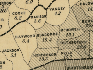
In the map of WNC, Rutherford County had the highest slave density. Madison County had the lowest slave density. In the map of Eastern North Carolina, Wake County had a slave density of 39.5 slaves. Franklin County had a slave density of 52.2 slaves. The main geographical difference between these two different sections of the state is the mountains. In WNC, there are a great number of mountains. In Eastern North Carolina, there are no mountains whatsoever. Slave plantations were mostly built in Eastern North Carolina, where many crops(like rice) were grown and cultivated by the slaves.

No comments:
Post a Comment